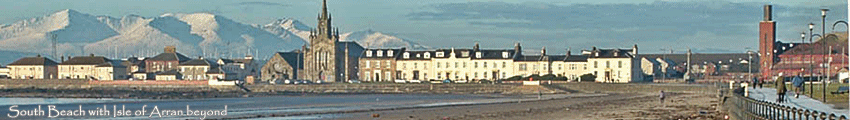
A Stroll round 1960s Saltcoats
-
reidsville
- Settling In

- Posts: 42
- Joined: Mon Sep 19, 2011 11:24 am
Re: A Stroll round 1960s Saltcoats
Yes P T I Was at St Peters from 1967/70 and remember at least once when we had our sports day at the Plantation
-
down south

- Mega Heid Poster

- Posts: 3543
- Joined: Mon Feb 16, 2009 4:18 pm
- Location: Cheshire,formerly Saltcoats
Re: A Stroll round 1960s Saltcoats
You certainly couldn't have used those sandpits for a long jump, PT; they were round and, as I say, seemed quite deep. Would have been fine if they were kept filled up to the top, but that didn't seem to be the case by then. Surprised nobody has remembered them.This Herald Files from 1947 would appear to refer to them; anyone remember there being a football pitch ?
" February, 1947. Improvements at the Holm Plantation being carried out by Ardrossan and Saltcoats town councils include the provision of two sandpits and a football ground for juveniles. "
They were around the same shape, and place, where I believe there are now some round flower beds, and I did wonder if they had been converted into those.
Meanwhile; yes, the black dot is indeed intended to be that drinking fountain you've remembered before; and you'll see there is another one at a junction of paths up on the hill, which did seem to strike a faint bell with me. I found them marked on another of the maps in " Old Maps ". a very detailed one of Ardrossan dated 1965 .
I got some of the path routes from that too, but I wasn't sure I agreed with them all ( ! ) . You'll probably have your own ideas about whether the path from South Beach Road gate to the bridge went off direct from the gate as they have it, or branched off a bit in from there as it does today; and on where the fountain was in relation to the paths.
Unfortunately there was no equivalently detailed map showing the Saltcoats end of the plantation ; but if there were at least two drinking fountains I'm sure there could well have been one at the Saltcoats end too.
And I have in the back of my mind that there may have been one somewhere beside the path running down from the steps to the white bridge ; perhaps someone may remember it.
Susan
Last edited by down south on Tue Mar 20, 2012 1:34 pm, edited 1 time in total.
-
peterm1711
- Regular Poster

- Posts: 276
- Joined: Sun Nov 22, 2009 6:56 pm
Re: A Stroll round 1960s Saltcoats
I can tell for absolute certain that St Peter's held their school sports in the Plantation in May or June, 1971.reidsville wrote:Yes P T I Was at St Peters from 1967/70 and remember at least once when we had our sports day at the Plantation
-
down south
- Mega Heid Poster
- Posts: 3543
- Joined: Mon Feb 16, 2009 4:18 pm
- Location: Cheshire,formerly Saltcoats
Re: A Stroll round 1960s Saltcoats
There was certainly no call for the Academy to use the plantation for sports by my day , of course; and even in the years before they had their own playing-field, among all the many odd fields and pitches around town that it seems were pressed into service there's no mention of it ever being used. Plenty of unofficial uses for it of course, as I've indicated above; a favourite place for pupils of all ages to hang out at lunctimes.
We didn't go for nature rambles there either; our classes in those days were way too big for that .And what wild flora and fauna were to be found there, rarely seemed to match up to the things we were told about in Nature Study. But there was, up in the wooded top corner, a very flourishing ( and noisy ! ) rookery.
You really felt you were in a wood there, back then; the trees were packed in closely, and you had to watch out for roots in the path. I remember yet the big sandy dip, outlined by roots, at the corner where the path skirted the back wall of the houses.
I remember too the tall metal gate, always open, at the topmost corner, and the big step down to the path there. And nailed high up on a tree just inside that gate, an old faded sign that always struck me as odd; because I'll swear it said " Trespassers Will be Prosecuted ".But the plantation was public open space; so what was that all about ? I suppose it could have meant trespassers into the house grounds ...or am I mistaken about what it said ? Perhaps someone else remembers .
Susan
-
geomacintyre

- Regular Poster
- Posts: 496
- Joined: Sat Dec 25, 2010 9:18 pm
- Location: Newcastle upon Tyne
- Contact:
Re: A Stroll round 1960s Saltcoats
Sorry Susan, just catching up on posts. If we can take a slight step back to the question of dykes, Lynne's post re Boyds of Ardrossan reminded me of the 1760s map of the area on page 6 of that topic - there is a clear reference to an area beyond the old washhouse that is referred to as Dyke. Transposed on to a modern map that looks as though it could be in the Laighdykes, Dykesmain area.
What we do for ourselves alone dies with us. What we do for others and the world remains and is immortal. - Albert Pine
-
down south
- Mega Heid Poster
- Posts: 3543
- Joined: Mon Feb 16, 2009 4:18 pm
- Location: Cheshire,formerly Saltcoats
Re: A Stroll round 1960s Saltcoats
Thank you George, that's very interesting. Seems very likely that's the right area; though of course it still doesn't explain why it was given that name.
Must confess, I hadn''t noticed that on the map; even though I'd been taking an interest in it recently and was just about to make use of it myself. See http://www.threetowners.net/forum/viewt ... 50#p103050
Susan
Must confess, I hadn''t noticed that on the map; even though I'd been taking an interest in it recently and was just about to make use of it myself.
Susan
-
down south
- Mega Heid Poster
- Posts: 3543
- Joined: Mon Feb 16, 2009 4:18 pm
- Location: Cheshire,formerly Saltcoats
Re: A Stroll round 1960s Saltcoats
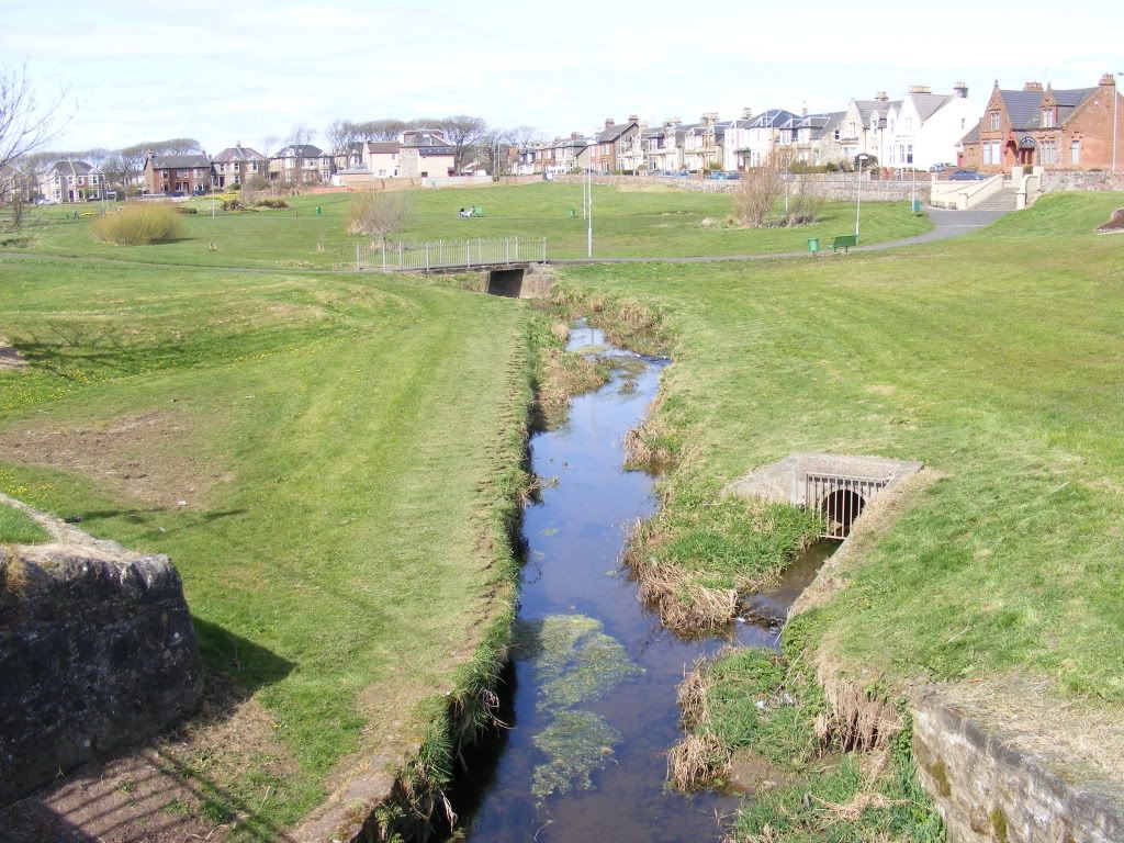
Returning to the plantation, there was one part of it which definitely did seem out of bounds back when I was young; and that's the section right at the Caledonia Road end, past the steps, which in those days was fenced off from the rest. You can see the fence here, a chain-link one with concrete posts, running right down beside the path to what was then a white wooden bridge over the burn:
There was a gate in the top wall, a wooden farm-type one, which was sometimes open; and a little plank bridge over the burn inside the boundary; but I always assumed it was somehow private and you weren't really supposed to go in ( not that any such thoughts stopped the local lads I used to see fishing in there....! ).
Back then I'd never heard of the famous Saltcoats Mineral Well, discussed and pictured in this earlier topic:
http://www.threetowners.net/forum/viewt ... 628#p77628"
but I'm sure now that this division had something to do with the fact that this area was where it stood, and used to be, as we've heard elsewhere ,separately owned by Saltcoats council. It was certainly fenced off back when the well was in commercial operation , as the picture with the post I've linked to shows.
As Scott's post about his wife's ancestors makes clear,selling water from the well was a cottage industry from way back; Well Cottage and the Chalybeate Spring beside it are marked on the 1860 map I mentioned earlier. And I've found a number of references to it in the Herald Files from the early 1900s, when apparently it was set up on a much more serious basis as a visitor attraction; to save making this post any longer I'm adding those to that Mineral Well topic.
All vanished without a trace now; or is it ? This picture of bigbaloo's seems to show a stream joining the burn at just about the right place to be the old mineral spring:
http://i879.photobucket.com/albums/ab35 ... ery006.jpg" onclick="window.open(this.href);return false;
Susan
Last edited by down south on Tue Jul 11, 2017 3:38 pm, edited 2 times in total.
Re: A Stroll round 1960s Saltcoats
Just catching up, so back to the "Scheme" above the High Rd where I grew up. Someone mentioned the "new" Adams Avenue shops. In the 60s these were (north to south): McGoogans (general grocery), Peggy's (bakery and sweetie shop -3d for a quarter poured into the Avery scale and then into a paper poke), Donalds Cafe (fish and chips, sweeties and "ginger" - I think an Italian family who changed their name, McQuaters (drapery), Andersons (newsagent, post office, stationery, fags, etc. and, finally, a two-shopfront Coop store. The part at the end of the block had a delivery door highish on the side wall and the store had a pulley driven cash transfer system to and from the cash desk to the left as you entered. The cash desk was a wooden cubicle with frosted glass. The white marble counter had a big lump of butter from which the grocer would form and wrap smaller portions using butter pats. Can't remember what the second Coop shop was used for.
Someone also mentioned the Springvale Nursery. Bounded by Ross Rd (north), Saughtree Ave. (east), Links Road (south) and McGillivary Ave (west). A high wall all round lent a sense of mystery. My ma used to send me occasionally to take things to a Mrs Walker, I think. Was her husband the caretaker? Think his name may have been Jack. Used to enjoy it as I'd get a Blue Riband (chocolate biscuit for those unaware). Remember my granda as a watchman when the houses at the top end of McGillivary were being built (late50s, early 60s?). Happy days!
Someone also mentioned the Springvale Nursery. Bounded by Ross Rd (north), Saughtree Ave. (east), Links Road (south) and McGillivary Ave (west). A high wall all round lent a sense of mystery. My ma used to send me occasionally to take things to a Mrs Walker, I think. Was her husband the caretaker? Think his name may have been Jack. Used to enjoy it as I'd get a Blue Riband (chocolate biscuit for those unaware). Remember my granda as a watchman when the houses at the top end of McGillivary were being built (late50s, early 60s?). Happy days!
-
down south
- Mega Heid Poster
- Posts: 3543
- Joined: Mon Feb 16, 2009 4:18 pm
- Location: Cheshire,formerly Saltcoats
Re: A Stroll round 1960s Saltcoats
Thanks for all that great detail, Howiesboy; I've added a link to here from the earlier post.
And back now to the Bute Terrace entrance of the plantation. Not all that much changed today; as I look at this I can still hear the rattle of the signals changing as we went by so close to the line:
http://maps.google.co.uk/maps?q=Saltcoa ... 64,,0,2.87" onclick="window.open(this.href);return false;
The wire netting beside the railway line was the same then. On the other side of the path a metal post-and-rail fence ran right along, with a gap further up as the plantation entrance; there were big railings at the end here, with no way in as there is today. The path was unsurfaced , and full of curious nobbly lumps not entirely comfortable to the feet; not something I ever met anywhere else .
And up till the mid-sixties or so it didn't just lead into the plantation ; you could also go from there straight onto the South Beach station platform. So let's sneak on there and look around.
Where the first thing we see is the long-vanished station bridge that used to be at this end. Say hello to Muffin again as we take a look at it in close-up:
The famous Iron Bridge was just a short way down the track, but this by rights should have had an even better claim to that name. Because the Iron Bridge, while it had a metal superstructure, had steps and top platform boarded with wood . Whereas this station bridge had even those parts made out of metal plates riveted together. Must have been pretty slippery sometimes I should have thought. But I don't remember ever feeling any special anxiety about that, all the many times I crossed it; back in those sixties days when it was still a readily accessible shortcut .
Susan
Last edited by down south on Mon Jul 10, 2017 3:41 pm, edited 1 time in total.
-
little plum

- Mega Heid Poster
- Posts: 3360
- Joined: Tue Mar 18, 2008 12:51 am
Re: A Stroll round 1960s Saltcoats
Susan, there's a vetenary practice along there that I,ve used on and off for 30 odd years. Would it be there in your 60's stroll.down south wrote: And back now to the Bute Terrace entrance of the plantation. Not all that much changed today; as I look at this I can still hear the rattle of the signals changing as we went by so close to the line:
Susan
------------------------------------------------------------------------------------------------------
The trouble with retirement is that you never get a day off - Abe Lemons
The trouble with retirement is that you never get a day off - Abe Lemons
-
down south
- Mega Heid Poster
- Posts: 3543
- Joined: Mon Feb 16, 2009 4:18 pm
- Location: Cheshire,formerly Saltcoats
Re: A Stroll round 1960s Saltcoats
Trust Muffin to make you think of the Bute Terrace vets', LP. I WAS going to mention it at some point, honestly.... We've had some discussion about it before, here in the topic " Three Towns Veterinarians ";
http://www.threetowners.net/forum/viewt ... 85#'p79685
and at the era we're talking about the vet was Mr Kennedy. But he didn't move into Bute Terrace until sometime at the start of the 1970s; I remember the surgery being opened there just before we moved, when we were consulting about how to ease the trip for our pet cat Topsy.
In the 1967 and 1970 phone books he's listed as being at 28 Eglinton Road, Ardrossan ( and we must already have been clients, because he's one of the numbers my Mum's written on the front cover for easy reference ), and he also had a branch at West Kilbride. Presumably he moved house and had the surgery built at the bottom of the garden.
PS I now have the exact details of the opening of the Bute Terrace surgery, in the form of this advertisement ( I knew I'd seen it somewhere, but I wasn't sure how easily I'd be able to find it ); as you can see it was in 1971.
PPS Mr Botcherby, the other local vet mentioned in the topic linked to above,was also still active in 1967; he too lived in Caledonia Road, but further along at No 42 .
Susan
http://www.threetowners.net/forum/viewt ... 85#'p79685
and at the era we're talking about the vet was Mr Kennedy. But he didn't move into Bute Terrace until sometime at the start of the 1970s; I remember the surgery being opened there just before we moved, when we were consulting about how to ease the trip for our pet cat Topsy.
In the 1967 and 1970 phone books he's listed as being at 28 Eglinton Road, Ardrossan ( and we must already have been clients, because he's one of the numbers my Mum's written on the front cover for easy reference ), and he also had a branch at West Kilbride. Presumably he moved house and had the surgery built at the bottom of the garden.
PS I now have the exact details of the opening of the Bute Terrace surgery, in the form of this advertisement ( I knew I'd seen it somewhere, but I wasn't sure how easily I'd be able to find it ); as you can see it was in 1971.
Susan
-
down south
- Mega Heid Poster
- Posts: 3543
- Joined: Mon Feb 16, 2009 4:18 pm
- Location: Cheshire,formerly Saltcoats
Re: A Stroll round 1960s Saltcoats
I believe I've heard somewhere that South Beach Station has the longest station platform in Scotland outside the big cities, built to accomodate the extra-long trains packed with trippers that used once upon a time to disgorge their hordes of passengers at this nearest stop to the sands.
And I can well believe it; short cut there may have been onto the platform at the Saltcoats end,but it was a very long trek from there up to the station buildings at the far end by South Beach Road bridge. Up till the late sixties the main ticket office was still the original wooden building you can see here; at the same spot as that glorified bus shelter that's there now.
In 1885, when the station was built , it seemed reasonable enough to put it on the Largs platform, because none of the houses around the plantation had yet been built, so few people would have been approaching to buy tickets from that side . But it was never a very convenient arrangement for anyone wanting to travel in the Glasgow direction.
There were white-picket-fenced steps up to the South Beach Road bridge on both sides , which made crossing to the other platform that way a bit quicker than going right round by way of the ground-level entrances; it was certainly less of a trail than using the station bridge at the far end. Or of course in those days you were not actively forbidden to cross the line direct, and there was a boarded pathway to help those who cared to judge the risks ... :
http://www.railbrit.co.uk/imageenlarge/ ... p?id=37521
And to complete the picture of the station in the earlier part of 1960s, there was also a small waiting-room on the Glasgow platform . There are good views of it in these two 1950s pictures posted earlier by Tom McGrattan:
http://www.threetowners.net/forum/viewt ... 568#p11568"
Susan
And I can well believe it; short cut there may have been onto the platform at the Saltcoats end,but it was a very long trek from there up to the station buildings at the far end by South Beach Road bridge. Up till the late sixties the main ticket office was still the original wooden building you can see here; at the same spot as that glorified bus shelter that's there now.
In 1885, when the station was built , it seemed reasonable enough to put it on the Largs platform, because none of the houses around the plantation had yet been built, so few people would have been approaching to buy tickets from that side . But it was never a very convenient arrangement for anyone wanting to travel in the Glasgow direction.
There were white-picket-fenced steps up to the South Beach Road bridge on both sides , which made crossing to the other platform that way a bit quicker than going right round by way of the ground-level entrances; it was certainly less of a trail than using the station bridge at the far end. Or of course in those days you were not actively forbidden to cross the line direct, and there was a boarded pathway to help those who cared to judge the risks ...
http://www.railbrit.co.uk/imageenlarge/ ... p?id=37521
And to complete the picture of the station in the earlier part of 1960s, there was also a small waiting-room on the Glasgow platform . There are good views of it in these two 1950s pictures posted earlier by Tom McGrattan:
http://www.threetowners.net/forum/viewt ... 568#p11568"
Susan
Last edited by down south on Tue Jul 11, 2017 3:39 pm, edited 1 time in total.